|
Government support of the mining industry has taken many forms, including road building. While it is true that the roads that have been driven into the North serve also the local people, and especially the tourist trade, they also serve to open up the country to prospecting and mineral development. One such road is the Hanson Lake Road, from Prince Albert to Flin Flon, with a special kind of history. Lew Parres, the well-known geologist from Flin Flon, northern prospector Olaf Hanson, and the writer, were all close to the planning of the road. First, Lew Parres says . . . . 1955 was the start of the Hanson Lake Road from Prince Albert to Flin Flon. At the time, the Chamber of Commerce in Flin Flon was pushing number 35 highway which went out to Beaver Lake then on across a very swampy area traversed by very deep rivers, through to Nipawin. Knowing that we had a potential mine in the Hanson Lake area, you and I - you were working with me at the time - we wanted to make sure that the road went west from here, if at all possible. So we got together because the route west would go through Precambrian rock rather than muskeg, the potential for fishing, mining, and lumbering was far greater. Going south through this muskeg there was no timber or fishing, no tourist attraction whatsoever, nothing. 
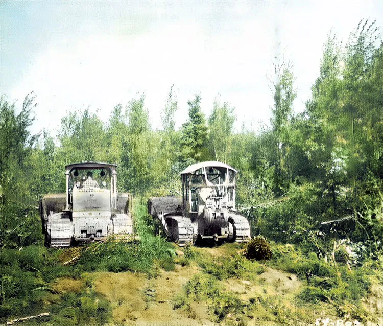
If you recall, we had some discussions between us and decided the thing to do was to call in a man who knew the area very well and discuss it with him. We got Olaf Hanson, and we met in my office, and we went over the map and Olaf outlined to us where the timber was thick, where the fishing was best, since he had trapped out there, and Hanson Lake has been named after him. As a result of this, I phoned Mr Brockelbank, who was Minister of Mineral Resources at the time, and Vern Hogg, his Deputy Minister, and suggested that they come up. The Flin Flon Chamber of Commerce proceeded to vote to put the highway through to Nipawin, of course, we had to buck this right from the start. You and I, Berry, were both excommunicated from society around Flin Flon for a while. But anyhow, we eventually got Mr Brockelbank and Vern Hogg up, Vern had been a classmate of mine, so it was a kind of reunion in one way. They spent a few days in Flin Flon going over the maps, and from that day the other road, number 35, was cancelled, and the Hanson Lake Road12 was decided upon, just the way you, Olaf, and I had planned it. Olaf did the guiding for the construction, he got a good job out of it. And then there was Olaf Hanson, of the Hanson Lake Road, who still as far as I know, goes out in the bush prospecting. People with a dream, an idea, or whatever it is that keeps them going, wonderful people that way - Helga Reydon.
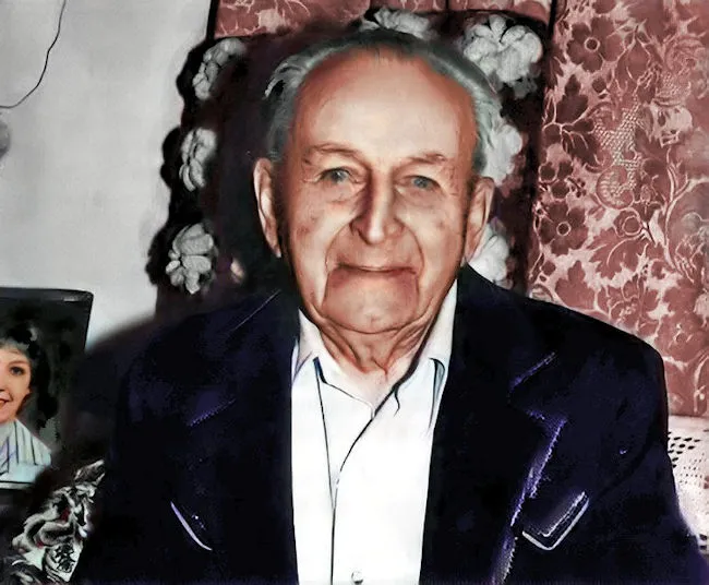
Olaf Hanson, photo courtesy Prince Albert Daily Herald. A. LEW PARRES.
The Parres family is well-known to the Canadian mining fraternity, having participated in a number of rushes in famous mining camps across Canada. Lew Parres first began prospecting in the early years of the Depression. Accompanying his father, C. R. Parres, and his brother, Jim, Lew took part in development work on claims at Snow Lake, Manitoba (which later became the Nor-Acme Mine); Beaver Lake, Saskatchewan; and Kississing (Cold Lake), Manitoba. During this time they trenched by hand-steel and blasted on gold discoveries made by Lew's father. While attending the University of Saskatchewan in 1934, Lew was a member of an expedition composed of students and directed by his father. Travelling by canoe down the Saskatchewan River to Beaver and Snow Lakes, the party drilled, blasted and trenched on the Parres properties. This exploration venture proved to be inspirational for many of the crew, particularly Waldo Clarke, Earl Crull, Chuck Donald, Rus Garnett, Bill Robinson, Jim Robinson, Jim Scott, Mel Thompson, and Lew's brother, Jim, who all went on to carve out successful careers in mining. The following year, Lew took part in mapping the Churchill River in Saskatchewan for the Geological Survey of Canada. In 1938, he returned to Snow Lake with Eric Swanson to map and trench on the Nor-Acme Gold Mines property. It was optioned to Howe Sound Mining Company in 1941 and put into production seven years later. For the next ten years, over five million tons were mined. More recently, the Hudson Bay Mining and Smelting Company carried out a deep drilling program on this property with encouraging results. Lew Parres serves as president of Nor-Acme. Another major rush that Lew Parres was involved in was that of Mystery Lake" in the late 1940s. At this time he discovered what "mystery" lay behind the lake's name: Walter Johnson, Neal Thurber and I were completing the staking of the west bay of Mystery Lake, we decided to have lunch on a sand beach located just west of the north narrows. We landed on the sand beach and noticed an odd six-by-two foot, rectangular growth of grass and muskeg. It appeared at first that this queer formation had either floated there or was the result of erosion. Later it was determined that it had floated there from some other location. Upon digging into the grass and moss we discovered that it was the grave of a person who had been murdered. We found a knife in the ribs and a pipe in a pocket. The pipe, which I still have, was carved from a rock high in talc, the police were notified and the body was removed. The story is told that the reason the name "Mystery Lake" was chosen is that two trappers went into the bush a number of years ago, but only one came out so it was a mystery as to what had happened to the missing trapper. It is believed we solved this mystery by finding the corpse on the sandy beach. In the 1950s, Mr. Parres was active in a variety of mining camps, including Thompson, Hanson Lake, and the Prince Albert area (in particular the Choiceland deposit). He discovered the Pinebay orebody in 1967, which is presently under option to the Hudson Bay Mining and Smelting Company and being developed with deep diamond drilling planned for the winter of 1981. Hudson Bay had surveyed the property prior to Parres' arrival, using the original Boliden Horizontal Loop method with a penetration of about 90 feet. Parres, however, used a Ronka Horizontal Loop method, which had a penetration ability of about 150 feet, the main part of the Pinebay orebody proved to be lying 149 feet below the ice surface. Mr. Parres, a longstanding director and member of the Prospectors and Developers Association, keeps very busy these days, with interests in a gold and silver mine in Nevada, as well as another two prospects in silver and a gold placer. Parres' Nor-Acme continues development of its potentially large gold prospect. - (Excerpts from Hanula et al., 1982, p. 280-282) Olaf Hanson himself recalls the time when the Hanson Lake Road was planned and located and says . . . . I first moved into that area in 1932, so I knew the country. I was prospecting and trapping, and working with Jim Fairburn and Fred Vichy. At first, I never dreamt about a road being there, I didn't pay much attention to it until I did some diamond drilling for Mid-West Diamond Drilling Company and Berry Richards, and he said "You know that area, where would there be a good road?" And I said "Yes: I know the country." Can you locate on a map a good route?" I agreed and you brought all the maps to the drill camp. So I marked the maps and thought no more of it until later when it was decided to build the road. That was in 1955 after I had located the road from Lynn Lake, Manitoba, to Co-op Point [now Kinoosao - WK], on Reindeer Lake, in Saskatchewan. Just out of Flin Flon, they had quite a time because it was a pretty rough place. Creighton Lake was dammed and they had a hard time crossing, so they asked me to locate the road, to get around it. I walked around and got a pretty good route without crossing the wet swamp, and they asked me if I would go on and locate the road. Which I did. I just walked ahead and blazed trees, to show where the best location was, to avoid the rocky hills, to avoid the muskegs. And we had to go around the lakes. It was called the Hanson Lake Road. 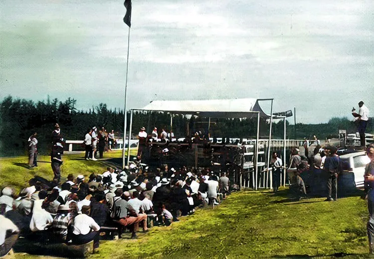
HANSON LAKE ROAD.
This 225-mile road between Smeaton and Creighton, providing a direct link between Prince Albert and Flin Flon, was officially opened on July 25, 1965. The project was started in July 1958 under the Federal-Provincial Road to Resources program. Built by the Construction Branch of the Saskatchewan Department of Natural Resources, it was turned over to the Department of Highways and designated 106 Highway. This road traverses a land rich in resources and opens up a vast area of fishing, hunting, prospecting and mining.
Text of a plaque located at Gillingham Lake, Hanson Lake Road.
OLAF HANSON.
The Hanson Lake Road was named after Olaf Hanson, a veteran trapper, prospector and outdoorsman, who spent many of his years in the area between Flin Flon and Smeaton. He also assisted the Construction Branch of the Saskatchewan Department of Natural Resources in building the road, taking part in locating and supervising blasting crews where the road traversed part of the Canadian Shield. His knowledge of the area was invaluable as the road crossed large areas of muskeg, lake and river as well as rocky outcroppings. It is a fitting tribute to Olaf Hanson that he lent his name to this road. |
Questions - Comments?


Links to all jkcc.com Webpages:
| Ausland Lake |
Northern Saskatchewan
| Deep River Fur Farm |
| Deep River Trapping Page |
| Deep River Fishing Page |
| My Norwegian Roots |
| Aasland Farm, Norway |
| My Norwegian Family |
| Early Mink of People Canada |
E. Rendle Bowness
| The Manager's Tale |
Hugh McKay Ross
| Sakitawak Bi-Centennial |
200 Year History.
| Lost Land of the Caribou |
Ed Theriau
| A History of Buffalo Narrows |
| Hugh (Lefty) McLeod |
Bush Pilot
| George Greening |
Bush Pilot
| Timber Trails |
A History of Big River
| Joe Anstett, Trapper |
| Bill Windrum, Bush Pilot |
| Face the North Wind |
By Art Karas
| North to Cree Lake |
By Art Karas
| Look at the Past |
A History Dore Lake
| George Abbott |
A Family History
| These Are The Prairies |
| William A. A. Jay, Trapper |
| John Hedlund, Trapper |
| Deep River Photo Gallery |
| Cyril Mahoney, Trapper |
| Saskatchewan |
A Pictorial History
| Who's Who in furs |
1952 to 1956
| A Century in the Making |
A Big River History
| Wings Beyond Road's End |
| The Northern Trapper, 1923 |
| My Various Links Page |
| Ron Clancy, Author |
| Roman Catholic Church |
A History from 1849
| Frontier Characters - Ron Clancy |
| Northern Trader - Ron Clancy |
| Various Deep River Videos |
| How the Indians Used the Birch |
| The Great Fur Land |
| The Death of Albert Johnson |
| A Mink and Fish Story |
Buffalo Narrows
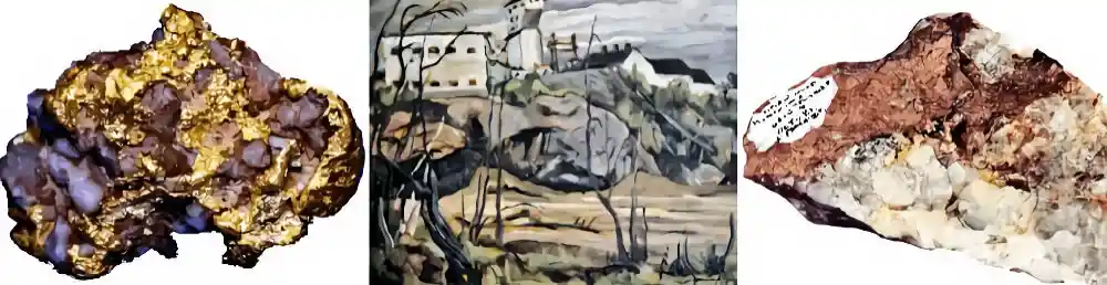
| Gold and Other Stories |
Berry Richards
| Saskatchewan James Carnegie |
| Ausland Lake |
Northern Saskatchewan
| Deep River Fur Farm |
| Deep River Trapping Page |
| Deep River Fishing Page |
| My Norwegian Roots |
| Aasland Farm, Norway |
| My Norwegian Family |
| Early Mink of People Canada |
E. Rendle Bowness
| The Manager's Tale |
Hugh McKay Ross
| Sakitawak Bi-Centennial |
200 Year History.
| Lost Land of the Caribou |
Ed Theriau
| A History of Buffalo Narrows |
| Hugh (Lefty) McLeod |
Bush Pilot
| George Greening |
Bush Pilot
| Timber Trails |
A History of Big River
| Joe Anstett, Trapper |
| Bill Windrum, Bush Pilot |
| Face the North Wind |
By Art Karas
| North to Cree Lake |
By Art Karas
| Look at the Past |
A History Dore Lake
| George Abbott |
A Family History
| These Are The Prairies |
| William A. A. Jay, Trapper |
| John Hedlund, Trapper |
| Deep River Photo Gallery |
| Cyril Mahoney, Trapper |
| Saskatchewan |
A Pictorial History
| Who's Who in furs |
1952 to 1956
| A Century in the Making |
A Big River History
| Wings Beyond Road's End |
| The Northern Trapper, 1923 |
| My Various Links Page |
| Ron Clancy, Author |
| Roman Catholic Church |
A History from 1849
| Frontier Characters - Ron Clancy |
| Northern Trader - Ron Clancy |
| Various Deep River Videos |
| How the Indians Used the Birch |
| The Great Fur Land |
| The Death of Albert Johnson |
| A Mink and Fish Story |
Buffalo Narrows
| Gold and Other Stories |
Berry Richards
| Saskatchewan James Carnegie |